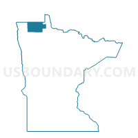
Strathcona Voting District, Roseau County, Minnesota
About
Outline

Summary
| Unique Area Identifier | 604122 |
| Name | Strathcona Voting District |
| County | Roseau County |
| State | Minnesota |
| Area (square miles) | 0.49 |
| Land Area (square miles) | 0.49 |
| Water Area (square miles) | 0.00 |
| % of Land Area | 100.00 |
| % of Water Area | 0.00 |
| Latitude of the Internal Point | 48.55384510 |
| Longtitude of the Internal Point | -96.16721200 |
Maps


Graphs
Select a template below for downloading or customizing gragh for Strathcona Voting District, Roseau County, Minnesota